AR Influence on River Ice
2025-02-15 00:00:00 -0500
Limber, R., Massoud, E. C., Guan, B., Hoffman, F. M., & Kumar, J. (2024). Influence of atmospheric rivers on Alaskan river ice. Geophysical Research Letters, 51, e2024GL111544. https://doi.org/10.1029/2024GL111544
Precipitation during the coldest months delays the annual breakup date of river ice, precipitation close to the breakup date has less impact. The Science
Atmospheric rivers (ARs) are large storm systems originating in tropical and midlatitude regions capable of depositing large amounts of precipitation in high latitude regions. The researchers identified 26 locations across Alaska USA that had a complete or near complete time series of observed annual river ice breakup dates from the National Weather Service, Alaska-Pacific River Forecast Center. They then proceeded to perform a correlation analysis comparing the timing of the annual river ice breakup and the estimated thermal energy exchange between the river ice surface and precipitation using Daymet meteorological data. In addition, the authors used statistical analysis to determine: the magnitude and duration, that ARs influence near surface air temperature; the proportion and interannual variability of total precipitation, that ARs account for.
The Impact
Using a paired t-test with an AR event as the treatment, it was found that ARs increase daily minimum temperature by as much as 1.3 °C (assuming a 3 day window) and increase maximum daily temperature by as much as 0.67 °C (assuming a 4 day window). This temperature increase brought on by ARs appears to persist for about a week in both the minimum and maximum daily temperature variables with a more extreme impact in both magnitude and duration in daily minimum temperature. Using linear regression, it was found that ARs explain 47% of interannual variability. From exploratory analysis, ARs account for 40% of total precipitation annually and make up 59% of extreme precipitation events (top 5% of precipitation events). From the Wilcoxon rank-sum test, ARs tend to account for far greater precipitation than non-AR related precipitation. Using an estimate of heat transfer between precipitation and the river ice surface, it was found that all precipitation (AR or non-AR) happening during the coldest time of the year (typically between late November and early February) have the greatest absolute correlation with breakup timing, showing a strong inverse relationship. Precipitation occurring closer to the breakup had little correlation.
Summary
Leveraging river ice breakup data throughout Interior Alaska (AK) the authors set out to explore the relationship between ARs and annual river ice breakup timing from 1980 to 2023. They found that daily air minimum air temperature increases can last up to 13 days after an AR event. ARs account for 40% of total precipitation, explain 47% of the variability of precipitation, and make up 59% of extreme precipitation events, on average annually. Using the mass and temperature of precipitation accumulated on the river ice surface, the authors approximated thermal energy exchange between precipitation and the river ice surface. The magnitude of energy exchange was then correlated to river ice breakup timing. It was found that greater amounts of precipitation from both AR and non-AR induced precipitation, occurring relatively close to river ice breakup dates have little correlation to the breakup date. However, increased precipitation during the coldest period of the year is strongly inversely correlated with river ice breakup timing and seems to delay the breakup date.
Forecast of Wildfire Potential Using a Tranformer
2025-02-14 00:00:00 -0500
Limber, R., Hargrove, W. W., Hoffman, F. M., & Kumar, J. (2024). Forecast of Wildfire Potential Across California USA Using a Transformer. Proceedings of the 2nd International Workshop on Big Data Analytics with Artificial Intelligence for Climate Change at IEEE Big Data 2024, IEEE, Washington, D.C., USA, pp. 4324–4332. DOI: https://doi.org/10.1109/bigdata62323.2024.10825778
Forecast of Wildfire Potential Across California USA Using a Transformer
Transformers can effectively emulate the US Forest Service’s Wildland Fire Potential Index maps using fewer, easier to obtain input variables, with improved computational efficiency
The Science
The authors used meteorological variables from Daymet, the normalized difference vegetation index (NDVI) calculated from the Moderate Resolution Imaging Spectroradiometer (MODIS) and the Scott and Burgan fire behavior fuel model from LANDFIRE, as inputs for a transformer with a residual connection to model Wildland Fire Potential Index (WFPI). The area of interest for this analysis was California USA. The US Forest Service’s WFPI maps were used to train the transformer. The transformer was tuned using Bayesian hyperparameter optimization with an architecture designed for time series analysis, whereby the past 30 days of inputs were used to forecast output for the subsequent WFPI value. Put more precisely, given the residual connection, the transformer outputted a bias that shifted “yesterday’s” WFPI, to align with what it perceived to be “today’s” WFPI values, thereby predicting subsequent WFPI values over the target region. This process can be repeated in series to forecast k days into the future. In this analysis k was restricted to seven to align with the forecast window of the US Forest Service’s WFPI model.
The Impact
Using open access meteorological variables, NDVI and the Scott and Burgan fire behavior fuel model, the transformer with a residual connection proved to be capable of effectively emulating the US Forest Service’s WFPI maps. Looking at a seven day forecast (equal to the forecast range of the WFPI model) for July of 2023, the transformer emulated maps compared to the WFPI modeled maps have correlations ranging between 0.85 - 0.98. The transformer can be easily parallelized and was able to predict seven day forecasts for each day of 2023 in only 6.5 minutes using two 64 core CPUs.
Summary
Wildfires are a major issue facing the United States. In California alone, wildfires are responsible for billions of dollars in damages and take lives each year. Accurately predicting fire danger conditions allows preparation awareness before wildfires start. Transformers are a class of deep learning models designed to identify patterns in sequential datasets. In recent years, transformers have gained popularity through their impressive performance in natural language processing and other applications of signal recognition. This analysis demonstrates the ability of a transformer with a residual connection to forecast fire danger potential over the state of California. WFPI maps collected from the US Geological Survey database from January 1st 2020 to December 31st 2023 were used to tune, train and evaluate the transformer. Meteorological inputs (provided by Daymet daily weather and climatological summaries), the NDVI calculated from MODIS, and the Scott and Burgman fire behavior fuel models (to characterize maps of fuel types), were used as inputs. Our results show that a transformer can effectively emulate the US Forest Service modeled WFPI maps of California USA for four week long forecasts over the month of July, 2023, with correlations ranging from 0.85 – 0.98.
Enhancing Photosynthesis Simulation Performance Machine Learning-Assisted Solvers

2025-02-13 00:00:00 -0500
Massoud, E. C., Collier, N., Sharma, B., Kumar, J., & Hoffman, F. M. (2024). Enhancing Photosynthesis Simulation Performance in ESMs with Machine Learning-Assisted Solvers. In 2024 IEEE International Conference on Big Data (BigData) (pp. 4351–4356). IEEE. https://doi.org/10.1109/bigdata62323.2024.10825207
Improvements in the efficiency of photosynthesis solvers within Earth System Models (ESMs) are achieved by integrating machine learning (ML) techniques, offering a data-driven approach to complement traditional numerical methods while preserving model physics.
The Science
This work integrates machine learning (ML) techniques into the photosynthesis solvers of the E3SM Land Model (ELM) to improve computational efficiency. By leveraging logged simulation data, neural networks (NN) and multi-linear regression (MLR) were developed to estimate optimal initial guesses for solvers at both leaf and canopy scales. These approaches maintain the model’s inherent physics while reducing solver iterations, showcasing how data-driven methods can complement numerical approaches in ESMs.
The Impact
The NN-based initial guesses reduced total solver iterations by 26.23% at the leaf level and by 2.62% at the canopy scale, while MLR achieved a 3.12% reduction at the canopy scale. These improvements enable faster model runs, reducing the computational cost and making high-resolution, long-term climate simulations more feasible. This work demonstrates how AI-driven approaches can complement traditional numerical methods, paving the way for more scalable and efficient Earth system modeling efforts that retain accuracy and reliability.
Summary
Earth System Models (ESMs) play a critical role in understanding and predicting climate dynamics. Photosynthesis simulations, a computationally intensive component of these models, were optimized in this study by implementing ML-based initial guesses for their solvers. Using logged data from point-scale simulations at the Duke site, NN and MLR models were trained to mimic solver response surfaces and estimate better initial guesses. This approach resulted in significant reductions in solver iterations, particularly at the leaf level, demonstrating the potential for ML techniques to accelerate ESM simulations while preserving model fidelity. These advancements not only enhance computational efficiency but also open pathways for integrating AI-driven solutions into other complex components of ESMs.
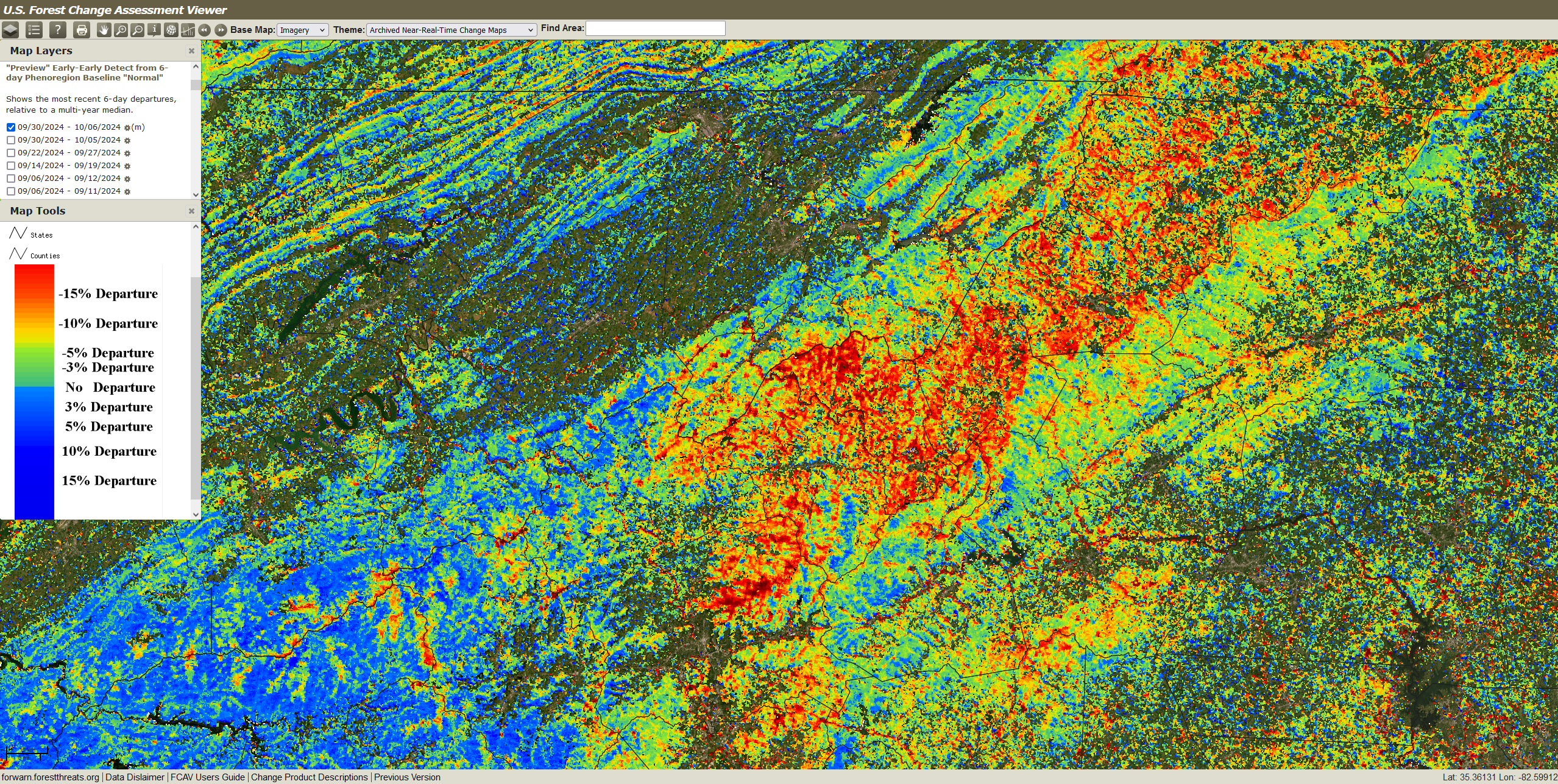
ForWarn tracks impact of Hurricane Helene
2025-01-07 00:00:00 -0500
ORNL Story: https://www.ornl.gov/news/forest-disturbance-tool-tracks-hurricane-helene-devastation
WVLT coverage of our work tracking Helene damage: https://www.wvlt.tv/2025/01/08/ornl-uses-forwarn-tool-help-depict-hurricane-helene-damage/
WATE coverage of ForWarn for assessing Helene impact: https://www.wate.com/news/anderson-county-news/ornl-tool-helping-resource-managers-track-helene-devastation/